Let’s say that you’re going on a 300 nm (550 km) flight — a typical distance for a cross-country trip in a small plane — VFR, without radar coverage. You file a flight plan, take off on time, but don’t arrive at your destination. A couple of hours after your planned arrival time, once flight services has completed a few phone calls (your destination airport, your cell phone, your emergency contact) and confirmed that you haven’t landed safely and forgotten to close your flight plan, a formal search begins.
Where do they look?
Point A to Point B
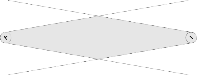
Let’s say that you filed your flight plan from Point A to Point B and that there are no obvious barriers (mountains, large bodies of water, restricted airspace). I’m not sure exactly how SAR works, but let’s assume that they’ll search within a 5 nm radius of each airport, and along your route of flight from those circles, allowing for a 10° drift in either direction. The search area appears in grey below (not to scale):
For a 300 nm flight, using my very rusty high school geometry skills, I calculate the search area to be nearly 9,500 nm²! That’s a lot of forest to search for a little plane with an unconscious pilot strapped into the front seat.
Point A to Point B (via Point C)
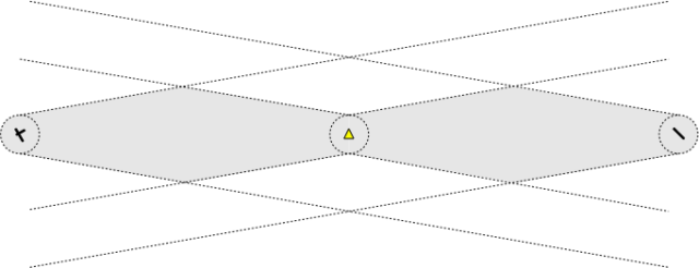
Fortunately, we can improve our chances quite a bit, simply by providing a checkpoint halfway through the flight:
Now that Search and Rescue knows that you intended to fly via Point C (represented by the yellow triangle), rather than, say, flying to the north for better scenery, or to the south to buzz your buddy’s cottage, they can anchor their drift lines at an additional point, cutting out a lot of search area (I’m still allowing a 5 nm circle of ambiguity around the checkpoint). I calculate that the search area is now reduced from nearly 9,500 nm² to just under 5,500 nm², a reduction of over 40% simply by adding one checkpoint in the flight plan.
Point C to Point B
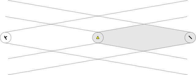
But wait, there’s more! Let’s say that, when you were over Point C (your midway checkpoint), you actually made a call to flight services and gave a position report. Now there’s no need to search anything before Point C, because they know you passed it before you made your forced landing:
You’ve reduced the search area from the original 9,500 nm² down to about 2,800 nm² — still a lot, but I’d bet more on your chances now. Simply choosing a checkpoint, and making a radio call over it, can make a huge difference.
Caveats, etc.
Flight following is an even better option, since ATC will know much more precisely where you disappeared from the radar. Unfortunately, flight following at lower altitudes is available only in highly populated areas. In Canada, below 10,000 ft you’re beyond radar coverage for much of the southern area of the country, not to mention the vast north. Even in the US, radar coverage can be spotty — I’ve fallen below radar at 7,000 ft when flying IFR in both Maine and New Hampshire, for example, reverting to non-radar reporting procedures.
A checkpoint makes sense only if you can report over it, which means that you need to be able to reach flight services, which is non-trivial at low altitudes away from populated areas. I plan my VFR flights with checkpoints that I know will be in range of an RCO or DRCO; if that doesn’t work, you can always try relaying your position report through another aircraft (air-to-air range is much further than air-to-ground).
Another interesting option for people who fly a lot in remote areas is the Spot personal messenger (site), which updates your position continuously via GPS and satellite and displays it on a web site. I haven’t tried it yet, but the price looks reasonable. It would be critical to mention the Spot in the remarks for your VFR flight plan, so that SAR would know to go to the site and check your flight path.


I have a spot and it works well. However, I never thought to include the url to the page on a flight plan, great idea!
Thanks, Blake. I’m getting more and more tempted by the Spot, myself. What I really want is affordable TCP/IP via satellite, so that we can have Internet-driven displays in the cockpit.
I was sold on spot until I read about how the spot system is entirely proprietary to their company and that it does not give off any “elt” type signal. It instead relies on breadcrumb trail that is uploaded over cellular networks as you fly along. I know my cell phone barely works in most places of Canada, how can we be sure Spot will? More doubt comes from here http://www.wildsnow.com/2323/plb-rescue-beacon-acr/
Guess 121.5 will have to stay in the Piper for now. Regardless of what the FCC likes to think about it!
Not sure what Viennatech is talking about. I have my SPOT on every time I fly in the Arctic Circle of Alaska and it has yet to fail reporting my position to the webpage. I also happen to use it for many other events in our area (including some involving actual searches) and have not had any problems. Our Regional SAR crew carry them as well. While they are proprietary, if you do happen to activate the emergency function the local authorities will be made VERY aware of the situation and position. I do not get any compensation from the SPOT company in any form. As the Fire Chief and SAR Coordinator for an area the size of the State of Indiana, I recommend SPOTs to anyone traveling in our very remote region of northwest Alaska where there are no roads to connect communities. SPOTs communicate with satellites, not cellular towers. Needless to say, we don’t have many cell towers out here in the tundra. On a more personal note, my better half gets rather upset when I forget to throw the SPOT in the dash of the plane. On the other hand, she also gets a little upset when I am late for dinner and she knows I landed in plenty of time (she watches the webpage when I’m flying) to get home on time. 🙂
Much-belated follow-up on the Spot. I did end up getting one, and it worked well for a number of years. After I upgraded to an IFR GPS (Garmin GTN 650) last summer, however, I was losing signal every ~10 minutes, and the GPS had to reestablish its satellites. It turned out that the 10-minute heartbeat from the Spot was interfering with the WAAS antenna, and that it’s a known issue with the GTN series. So I didn’t renew my subscription, and the Spot is just sitting in a Rubbermaid container now, with other unused flying stuff. I might try a Garmin InReach some time soon.