The #flightlog Twitter hashtag

I’ve used the hashtag #flightlog to post information about my last two flights to Twitter:

CYRO-CYAM VFR, 4.4 hours flight time (4.2 air time) PIC #flightlog

CYTZ-CYRO IFR 1.8 PIC in a PA-28-161 #flightlog

No one is using this hashtag for anything else, and it would make it easy for pilots to find other pilots on Twitter who’ve flown the same routes or used the same airports. So far, of course, I’m the only pilot to find.

Posted in General | Tagged , | 1 Comment

Why checkpoints matter

Let’s say that you’re going on a 300 nm (550 km) flight — a typical distance for a cross-country trip in a small plane — VFR, without radar coverage.  You file a flight plan, take off on time, but don’t arrive at your destination.  A couple of hours after your planned arrival time, once flight services has completed a few phone calls (your destination airport, your cell phone, your emergency contact) and confirmed that you haven’t landed safely and forgotten to close your flight plan, a formal search begins.

Where do they look?

Point A to Point B

Let’s say that you filed your flight plan from Point A to Point B and that there are no obvious barriers (mountains, large bodies of water, restricted airspace).  I’m not sure exactly how SAR works, but let’s assume that they’ll search within a 5 nm radius of each airport, and along your route of flight from those circles, allowing for a 10° drift in either direction.  The search area appears in grey below (not to scale):

Point A to Point B search area.

For a 300 nm flight, using my very rusty high school geometry skills, I calculate the search area to be nearly 9,500 nm²!  That’s a lot of forest to search for a little plane with an unconscious pilot strapped into the front seat.

Point A to Point B (via Point C)

Fortunately, we can improve our chances quite a bit, simply by providing a checkpoint halfway through the flight:

Point A to Point B via Point C search area.

Now that Search and Rescue knows that you intended to fly via Point C (represented by the yellow triangle), rather than, say, flying to the north for better scenery, or to the south to buzz your buddy’s cottage, they can anchor their drift lines at an additional point, cutting out a lot of search area (I’m still allowing a 5 nm circle of ambiguity around the checkpoint).  I calculate that the search area is now reduced from nearly 9,500 nm² to just under 5,500 nm², a reduction of over 40% simply by adding one checkpoint in the flight plan.

Point C to Point B

But wait, there’s more!  Let’s say that, when you were over Point C (your midway checkpoint), you actually made a call to flight services and gave a position report.  Now there’s no need to search anything before Point C, because they know you passed it before you made your forced landing:

Search area after making a radio call over Point C.

You’ve reduced the search area from the original 9,500 nm² down to about 2,800 nm² — still a lot, but I’d bet more on your chances now.  Simply choosing a checkpoint, and making a radio call over it, can make a huge difference.

Caveats, etc.

Flight following is an even better option, since ATC will know much more precisely where you disappeared from the radar.  Unfortunately, flight following at lower altitudes is available only in highly populated areas.  In Canada,  below 10,000 ft you’re beyond radar coverage for much of the southern area of the country, not to mention the vast north.  Even in the US, radar coverage can be spotty — I’ve fallen below radar at 7,000 ft when flying IFR in both Maine and New Hampshire, for example, reverting to non-radar reporting procedures.

A checkpoint makes sense only if you can report over it, which means that you need to be able to reach flight services, which is non-trivial at low altitudes away from populated areas.  I plan my VFR flights with checkpoints that I know will be in range of an RCO or DRCO; if that doesn’t work, you can always try relaying your position report through another aircraft (air-to-air range is much further than air-to-ground).

Another interesting option for people who fly a lot in remote areas is the Spot personal messenger (site), which updates your position continuously via GPS and satellite and displays it on a web site. I haven’t tried it yet, but the price looks reasonable. It would be critical to mention the Spot in the remarks for your VFR flight plan, so that SAR would know to go to the site and check your flight path.

Posted in General | Tagged , , | 5 Comments

The fuel and weight dilemma

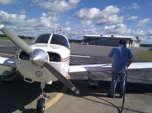
Fueling C-FBJO.

Last week I wrote about the summer flying dilemma, the challenge of balancing passenger comfort, speed, and the rising summer cumulus clouds. Pilots face a whole series of dilemmas like that with every flight — in fact, it’s probably fair to say that flying is more about finding balanced solutions to different dilemmas than it is managing the yoke, rudder, and throttle.

Weight vs. time

This week, I had to deal with a different challenge, the fuel and weight dilemma. A few years ago, I never had to worry about this one: my Piper Warrior can carry 665 lb when the fuel tanks are full, and that was enough for my whole family of four, our dog, and luggage, so filling the tanks for every flight was a no-brainer. Now my girls have grown into intelligent and beautiful women, and I’ve gone the other direction by putting on a few extra pounds, so I have to start thinking about fuel and weight.

Trade-offs

Here are the kind of options I consider before every flight:

Fuel Endurance Remaining load Can carry
48 gal 5:35 665 lb Family and nothing else.

Three of us and 150 lb luggage.

Me and 455 lb luggage.

35 gal 4:00 743 lb Family and 80 lb of luggage

Family, dog, and 40 lb of luggage

Three of us and 230 lb luggage

24 gal 2:40 809 lb Family, dog, and 105 lb luggage
20 gal 2:10 883 lb Family, dog, and 130 lb luggage

Additional considerations

You have to consider a few points when looking over these choices:

  • There is some stuff I have to carry in the plane — charts, Pilot Operating Handbook, tow bar, a couple of quarts of oil, some emergency supplies, cover, etc. That stuff weighs at least 20 lb even when I strip it to its bare minimum, so out of a 40 lb baggage load, only 20 lb would be available for bags — that’s 5 lb each for four people.
  • People rarely fly naked (which is a good thing, given the average pilot’s age). Even in the summer, clothes and shoes add an extra 5 lb per person, and people tend to carry purses or backpacks with food, books to read, etc., adding an extra 5 lb each.
  • For safety, you need to have a fuel reserve. The minimum required is 30 minutes (45 minutes at night) VFR, and more, including fuel to get to an alternate airport, IFR. For me, 2:40 fuel means at most a 1:40 flight VFR, and maybe 1:00 IFR, which isn’t enough to be useful for cross-country flying (a fuel stop every hour makes for a long flight).

There are yet other considerations. A lighter plane will take off in a shorter distance, climb faster, and cruise faster (I see a 5-10 knot difference in cruise speed between just me on board lightly loaded, and wallowing along at maximum gross weight). It costs time and money to tanker extra fuel along, and could also be a safety issue on a short runway, if there are trees looming at the other end.

The PIC’s burden

As with the summer flying weather dilemma, there’s no automatic right answer for this: that’s why you’re pilot-in-command — you have to think hard, and trade off one kind of safety or efficiency for another, hoping you’ve found the best balance. Airline pilots worry about this even more than small-plane pilots do: someone once pointed out to me that for a 747, every takeoff is a short-field takeoff.

This week, I got my whole family to Toronto and back safely, IFR both ways, landing with about 1:30 left in the tanks. It was nerve-wracking having to do such careful fuel management, and telling Porter FBO in Toronto the exact number of litres to put in each tank (rather than “fill ‘er up”), but it worked. My fuel burn was exactly as planned, we flew a bit faster for being light, and we got four adults back and forth in a 160 hp airplane.

Next week, it’s just me and the my 12-year-old Border Collie flying to the Soo. I’ve filled the tanks right up to the brim, and will fly the whole thing non-stop for four hours, IFR or VFR, while the old girl naps in the back seat.

Posted in General | Tagged , | 5 Comments

#1 again

That was fast! Barely are my blogs restored, and Google has already bumped this blog up to the #1 search result for the common aviation phrase “land and hold short”, ahead of the Wikipedia article (#2) and AOPA’s guide to land and hold short operations (#3). Thanks, GOOG.

Posted in General | Tagged | Leave a comment

The summer flying dilemma

On a typical VFR summer day in southern Canada or the northern US — the kind that the weather(wo)men call “a mixture of sun and cloud” with a decent amount of humidity — swirling columns of heated air, called thermals, start rising in the morning, and get higher and higher into the late afternoon as the sun warms the ground.

Clouds are the dividing line

At the top of those thermal columns, like scoops of ice cream on top of invisible cones, scattered cumulus clouds form. At first, those clouds might be only 1,000 feet thick and maybe 2,000 ft above the ground, but as the columns rise, the clouds get both higher and thicker, and some of them may develop into storm clouds during the afternoon (giving your typical cottage thunderstorm or 20-minute shower).

Underneath those clouds the horizontal winds are weaker, but the vertical motion of the thermals can cause a lot of turbulence — while the air may be smooth at breakfast, by early afternoon it can be rough enough to have passengers grabbing for the vomit bags, while the pilot feels like he or she is in a wrestling match with the yoke and rudder pedals.

Above the clouds, the air is normally smooth, but the winds are much stronger.

So where do you fly?

Flying eastbound

Eastbound, the best place to be is above the clouds if you (and your plane) can manage it. Prevailing summer upper winds in this part of the world are from the west or southwest, so on a good summer’s early afternoon you can get a 25-30 knot tailwind and smooth air at 9,500 ft eastbound. What’s not to love?

The problem is that the tops of those cumulus clouds keep getting higher and higher until almost supper time. In Canada, you need oxygen to fly above 10,000 ft for more than 30 minutes, and the tops of summer cumulus clouds could hit that height anywhere between 11:00 am and 2:00 pm, even ignoring isolated storm clouds. As the day goes on, without oxygen and a powerful plane, you hit a point that you can’t outclimb the clouds any more, and you’re forced to descend either into them (IFR) or under them (VFR), giving up some of the tailwind, and throwing you and your passengers back into the turbulence.

The good news is that, with the extra speed from the tailwind, you might be able to finish your trip before that happens. It’s possible to fly a Piper Warrior from Ottawa to Charlottetown in well under four hours with a good tailwind, so you can leave early in the morning, fly non-stop, and land for lunch before the clouds (and turbulence) outclimb you. Your passengers will have to put up with a bumpy descent and landing, but the rest of the flight will be smooth.

Flying westbound

Flying westbound, into the wind, you’re faced with a lose-lose proposition:

  1. Fly below the clouds to get weaker headwinds, but subject your passengers to stomach-emptying turbulence as the day goes on.
  2. Fly above the clouds to get smooth air, and watch your airspeed drop to (or below) automobile speeds.

First thing in the morning, you have a good chance to find both smooth air and weak headwinds at low altitudes (e.g. 2,500 ft), but that won’t last until lunch. As the cumulus clouds start to form, you’ll have to pick sides, diving down into the turbulence or climbing up into the headwinds. And to throw extra salt into your wounds, the headwinds slow you down and make it more likely that you’ll have to make a fuel stop, slowing you down even more, and pushing your flight later and later into the afternoon and the worst of the turbulence and/or headwinds. If you do decide to go above, even that won’t last: in a low-end plane without oxygen, you’ll eventually have to go down below and start banging your passengers’ (and your) heads against the ceiling of your plane.

Flying north- or southbound

In Canada, it’s safe to say that most cross-country flying is on the east-west axis, since Canadian cities are spread out in a thin line along the US border. In the US, on the other hand, you’re just as likely to be flying on the north-south axis (or something in-between). In that case, if the upper winds are from the southwest (typical in summer, at least east of the Rockies), then flying southbound will be a lot like flying westbound, but with less severe headwinds, while flying northbound will be like flying eastbound, but with less beneficial tailwinds.

Strategies

I fly some passengers who suffer from motion sickness, so I spend a lot of time planning around this stuff. In general, flying eastbound, I’ll go up above and accept a longer flight to get smooth air, since my passengers would rather be comfortable for 5-6 hours than violently ill for 3-5. Still, I can’t protect them from the turbulence when I have to land (fuel stop or destination).

Of course, I can’t stay above all day when the sun’s out — today, coming back from Charlottetown, I started at 2,500 ft in air so smooth you could do calligraphy in the back seat, but by late morning ended up at 10,500 ft over Quebec’s Eastern Townships trying to stay above the rising cumulus layer. Once my 30 minutes above 10,000 ft were up, I had to descend and subject my passengers to 40 minutes of turbulence below the clouds at the end of the flight.

If your schedule can handle it, there are some workarounds to minimize the damage:

  • Start as early in the morning as possible, if there’s no fog or low stratus. Some pilots I’ve met like to be preflighting as the sun rises. If your family is willing to wake up at 5:00 or 5:30 am, go for it, and the flight will be more fun (plus you’ll have more of the day at your destination).
  • If your route follows a shoreline or a wide river, fly over water instead of land (staying within gliding distance). Water tends to be cooler in the summer, and doesn’t throw up thermals as much. Often, the best break through a line of thunderstorms will be over water, but don’t let yourself get pushed offshore.
  • Fly in the evening, especially if you have a well-lit destination for landing after dark. Summer evenings are long-ish, and the air tends to start calming down again around 7:00 pm, give or take, as the ground cools, the thermals die out, and the afternoon cumulus clouds flatten out and disperse.
  • Split up the trip. Instead of two three-hour legs with a fuel stop on your westbound flight, fly halfway, land before lunch, and spend the day. The next morning (or that evening), fly the second leg in smooth air again. For example, I could have flown from Charlottetown to Quebec City, spent an afternoon and evening there, and then flown on to Ottawa the next morning.
  • Stay on top as long as possible, and descend quickly at your destination. For passengers who suffer from motion sickness, popping ears are far preferable to a long time down low in turbulence.
  • Take up soaring. Glider pilots love afternoon thermals, because the rising air lets them stay up almost indefinitely — that’s why you’ll often see gliders happy circling under a cumulus cloud, while pilots of powered planes are impatient to be back on the ground.

In the end, though, turbulence and headwinds are facts of summer flying, and not every day is a typical day — you could drag everyone out of bed at 4:30 or 5:00 am and still be in bumps the whole flight, and you could even end up with headwinds in both directions. Don’t pressure yourself to make the flight perfect and control things outside your control: just do your best with whatever you have to work with.

Posted in General | Tagged , , | 5 Comments

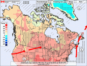
Thor doesn’t want you to fly today

So where would you fly in this? There are thunderstorms right across the country and well north of the Arctic Circle, and then snow.

(Source: Environment Canada, Canadian Weather at a Glance.)

Posted in Uncategorized | Tagged | Leave a comment

August flying

To celebrate the return of the Land and Hold Short blog after a hiatus of several weeks, I’ll list the airports I plan to fly to in August:

All of the trips will be starting from my home airport of Ottawa/Rockcliffe. I was thinking of trying to squeeze in a flight up north to Moosonee Airport as well, but I can’t see where I could fit it in.

Tagged | 1 Comment

Aztec single-engine takeoff

A Piper Aztec (not the accident aircraft).

I just noticed this now in Transport Canada publication. I’m reproducing it here because I cannot link to it directly (links added by me):

On August 24, 2009, the pilot of a privately-owned Piper PA23-250 arriving from the United States stopped in Brantford, Ont., to clear customs before continuing to his private strip. When the pilot was preparing to depart Brantford, he was unable to start the right engine. The pilot elected to attempt a single-engine takeoff from Runway 23. During the take-off roll, the pilot was unable to maintain directional control; the aircraft departed the right side of the runway just before the intersection of Taxiway Echo and Runway 23. The aircraft struck a taxiway light and continued across the taxiway before becoming airborne. The aircraft began a slow climb but was unable to clear trees at the edge of the airport property. The aircraft’s right wing struck a tree approximately 20 ft off the ground, severing the outboard portion of the right wing. The aircraft crashed into a cornfield approximately 300 ft beyond the tree and sustained substantial damage. The pilot was the only occupant on board and received minor injuries.

TSB File A09O0179.

You can search for the source on this page.

Note that the news story linked above claims that an engine “seized” shortly after takeoff, but the later TSB summary contradicts that. The newspaper version is more believable — it’s hard to imagine any pilot knowingly doing a single-engine takeoff in a light twin!

Posted in General | 5 Comments

Major Ottawa Airspace Change on 8 April

With almost no fanfare, there will be a major change in Ottawa’s airspace in a couple of weeks. Information about the change is buried deep in this PDF file (thanks to Blake Crosby for the heads-up). Here’s a page from the 8 April 2010 CFS with the new airspace:

In case the AIC link dies, or you don’t feel like searching the whole file, here’s the relevant text:

AERONAUTICAL INFORMATION CIRCULAR 4/10
OTTAWA/GATINEAU, QUÉBEC
CHANGES TO THE OTTAWA/GATINEAU CONTROL ZONE

NAV CANADA, the country’s provider of civil air navigation services, conducted an aeronautical study that evaluated the airspace and publications in Ottawa, Ontario and the surrounding airports. The study recommended changes to the airspace and publications for Ottawa International, Ottawa/Gatineau, Ottawa/Rockcliffe, and Ottawa/Carp airports. These changes will be implemented over a period of time.

The first planned change is to extend the Ottawa/Gatineau control zone south, to the south side of the Ottawa River, with an exclusion over the river at 700 feet above ground level (AGL) and below.
This change will take effect 8 April 2010 at 0901 Coordinated Universal Time (UTC). The appropriate
aeronautical publications will be amended.

For further information, please contact: […]

This may sound innocent enough, extending the Gatineau Airport control zone from the north shore of the Ottawa River less than a mile to the south shore, but it effectively closes off the only eastbound class G corridor out of Ottawa, one used very heavily by pilots from Rockcliffe Airport. This will now be mandatory frequency (MF) airspace while the Gatineau FSS is open, and we’ll all have to call Gatineau as soon as we take off from Rockcliffe.

Making an extra radio call isn’t a big deal, but I wonder how many Ottawa pilots will notice this change in the new CFS, or the AIC buried deep in that PDF file? I learned about it only because a pilot from Toronto told me. As far as I know, there has been no major effort to reach out and inform local pilots — no mention in emails from local flying clubs, blogs, etc., and the chief instructor at at least one of the local flying clubs was unaware this morning of when it was coming in or exactly what the change would be. I wouldn’t be surprised to see dozens of airspace vios after April 8, as pilots follow the same route they’ve followed for years without realizing they have to make a now-mandatory call to Gatineau. Normally, I’d have expected to be hearing about something like this for months before it happened.

Posted in General | 6 Comments

Online AIPs

I’m using this post as a place to accumulate links to different countries’ online Aeronautical Information Publications (AIPs), which include airport directories, diagrams, etc. I’ll start with a few, and add more countries as I have time, or as people leave comments with links:

Afghanistan
http://www.motca.gov.af/important_information.htm
Argentina
http://www.cra.gov.ar/dta/ais/inicio.php
Australia
http://www.airservicesaustralia.com/publications/aip.asp
Brazil
http://www.aisweb.aer.mil.br/aisweb/
Canada
Not available online; partial information is available here and here, but the actual directory of Canadian airports is paper-only, in the Canada Flight Supplement
Chile
http://www.aipchile.cl/dasa/aip_chile_con_contenido/index.php (limited number of airports)
China
Not available online
Denmark
http://www.slv.dk/Dokumenter/dsweb/View/Collection-95 (major airports only)
Estonia
http://aip.eans.ee/
Finland
https://ais.fi/ais/eaip/en/
France
http://www.sia.aviation-civile.gouv.fr/default_uk.htm
Germany
Military aerodromes: http://www.mil-aip.de/
Civilian aerodromes: not available online
Iceland
http://www.caa.is/FlugmalahandbokinAIP
Iran
http://ais.airport.ir/Homepage.aspx?site=ais.airport&lang=fa-IR&tabid=0
Netherlands
http://www.ais-netherlands.nl/
South Africa
http://www.caa.co.za/resource%20center/Charts/AERONAUTICAL%20CHARTS/charts%20index.htm
Posted in General | 16 Comments